Ever since arriving in Banff I had been eyeing the tallest
mountain in the area. It looked imposing
with steep, jagged peaks that towered 5,500 feet above the valley floor. It was also impressive on paper with an 8.4
mile round trip trail boasting 23% grade and topping out at over 9,750. Clearly I had to try it.
Our condo was about 2.5 miles away so the plan was to run
there, summit the mountain, run back. Pretty simple, right? I started around 7:45 and was treated to
local wildlife, waterfalls, and a lower layer of clouds down in the valley
before I even got started. Got to love
Banff!
After wandering around the golf course for a bit, I found
the correct fire road and soon was on the Mount Rundle summit trail. With 23% average grade, I was expecting super
steep forest trails similar to what I’ve run in the Alps. It was still a stout climb but was much
mellower than I had expected. I power
hiked and ran up, enjoying the views through the trees of the surrounding
mountains and valley cloud layer.
I was bouncing along having a great time and finally decided
to check the Suunto watch. I had gone 3
miles with 2,300 feet of climb. Not bad
under most circumstances, but I did some mental math and promptly got very
confused. So there must be more than 3,000
feet of climbing left but there simply wasn’t enough distance left for the rest
of the climbing. Clearly this must be a
much longer out and back than advertised.
No matter. I was making good time and would get it done anyway.
And then – WHAM!!! I
crossed a rockslide and was greeted with a sheer wall in front of my face. It was a mass of roots and impossible steep
forest trail climbing up. Game on! The grade was absurd, so I figured it would
have to let up soon. Well it did not.
The trail relentlessly pounded straight up the
mountain. No switchbacks and no
mercy. After forever I checked my watch
to discover I had gone only 0.5 miles.
What?! I looked again and saw I
had climbed over 1,200 feet, meaning it was a 47% grade through the trees.
I trudged up through the tree line and was greeted with
incredible views of the surrounding mountains.
I was also greeted with a clear view of the rest of the “trail.” It looked like a sheer rock face straight to
the summit with scree fields, rock and talus everywhere, and not a trail to be
found.
I figured I had seen worse in the Alps and trudged on. In truth I have descended down similar
terrain but had never climbed anything this tough. I kept pushing up, wondering
if I had lost my mind, and was pleased to see two people above me. It turned out they were a couple from Germany
and Australia, and I pushed past them after chatting but was glad to know I had
company on the mountain. It was also
getting very cold and windy, so I finally relented and put on my pullover.
The vertical insanity continued, and I eventually found
myself in view of the summit. The last
push was the toughest and steepest. I
struggled to move forwards and avoid falling back with the loose rocks and
talus. Finally, I hit an apex and saw
the summit was a short traverse over on the knife edge. I checked the watch and
was floored to see that I had covered over 3,000 feet in 1.2 miles for a 46%
grade. The trail was 4.2 miles one way
as advertised; my mind was blown.
The view was other-worldly from the top. I took some pictures and videos, enjoyed an
overly well earned PB&J, and tried my best not to freeze to death.
It was a cool perch, but I had to get warm and back to the
family. The first part of the descent
was tricky at best. But in the next
stretch I think I finally got the hang of descending down scree. I basically skied down the rocks and was
having a blast. The stretch after the
scree field was actually the toughest.
It was still super steep and all rocks, but there wasn’t much to get a
grip on or stop a fall. I fell here and
banged up my leg and elbow a bit but nothing major.
I hit the super steep forest trail and powered down as fast
as I could. My legs were definitely
feeling it after descending so much so quickly.
I finally hit the bottom of the steep section and the 3,000 foot 1.2
mile descent. My legs were shaking, but
I knew they’d come around on the less crazy trail. I motored down the last 3.1 miles in less
than 30 minutes and popped out on the golf course.
I ran a few miles to meet up with the family in town. It was a wild ride, and I am still glowing
from the adventure. Aside from being
crazy fun, I also feel like I am slowly improving on the extreme terrain and
can do ok on tough courses.
And a huge thanks to Jen for giving me the morning off! Super happy to have had the chance for this
big adventure.

Leaving the condo. The summit of Mt Rundle was shrouded in clouds.

Cascade Mountain in early morning light

Ran through Banff and crossed the Bow River. The highest point here is the beast I'll be climbing.

Bow River Rapids. Didn't know these were here, so it was a nice bonus!

The famous Fairmont Hotel.

Came around the corner and saw a huge elk!
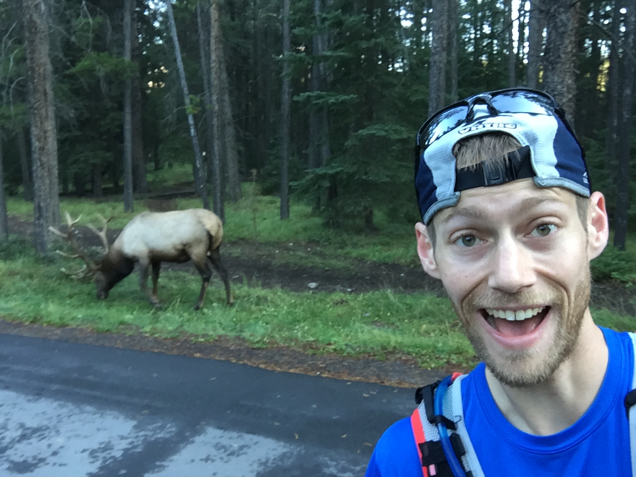
Since this elk was hanging out around a golf course, I figured it was tame and took a long distance elk selfie.

Climbing up through the trees and looking out at the low cloud layer in the valley.

Cloud layer over the town of Banff.

"The Wall." After the mellow forest trail this was the real deal. Hard to get scale, but this was 45%+ grade straight up the forest.

Starting to break above treeline

Looking down at the town of Banff

Working the climb hard but loving it!

The "trail" up the rock / scree field to the summit.


Looking down the rock field I climbed up and starting to get bigger views

The route to the top. I was very happy to see two other souls out here. It was a nice couple from Australia and Germany.

Looking down the route up. You can see the two small dots of the people in the previous pic that I had now passed.

Looking over at the route up the smaller summit of Rundle, which was less steep than the one I was on.

Still on the way up and looking over at the spine of the smaller Mt Rundle summit.

Another view down the route. I had come up from the bottom and then turned over to where I was now. It was getting really cold and windy up here!

View from just short of the summit

At the top now!

Looking off the back side of Rundle. Basically a vertical wall!

Traversing over to the official summit. You can see the route I climbed going from bottom left to middle right.

A bunch of glorious views from the top! I was very cold but stopped to enjoy a PB&J and revel in the spectacular 360 degree panorama.


A few views down the backside to the river 5,500+ feet below.


You could see some big peaks and big glaciers in the far distance that were tough to capture in the picture


On the way back down. Good view of the crazy steep descent from the summit. Basically had to ski down the rocks and brace with the trekking poles.

Way too happy. Digging the adventure!

Looking up the route I descended. We came down the ridge on the left from the peak in the top right. I later found out that one should not descend into the gully at any cost. Glad I didn't!

Navigating down to the tree line. Took a nice spill on this section.


Past "the wall" now and moving fast down the last 2,300 feet. Loving this forest trail.

Some sweet single track in the sub alpine.

Back to the valley! Looking across the golf course to the Fairmont.

Running back into down and looking up a the summit of Rundle with new perspective / respect.

Later in the week we got a great view of the mountain.
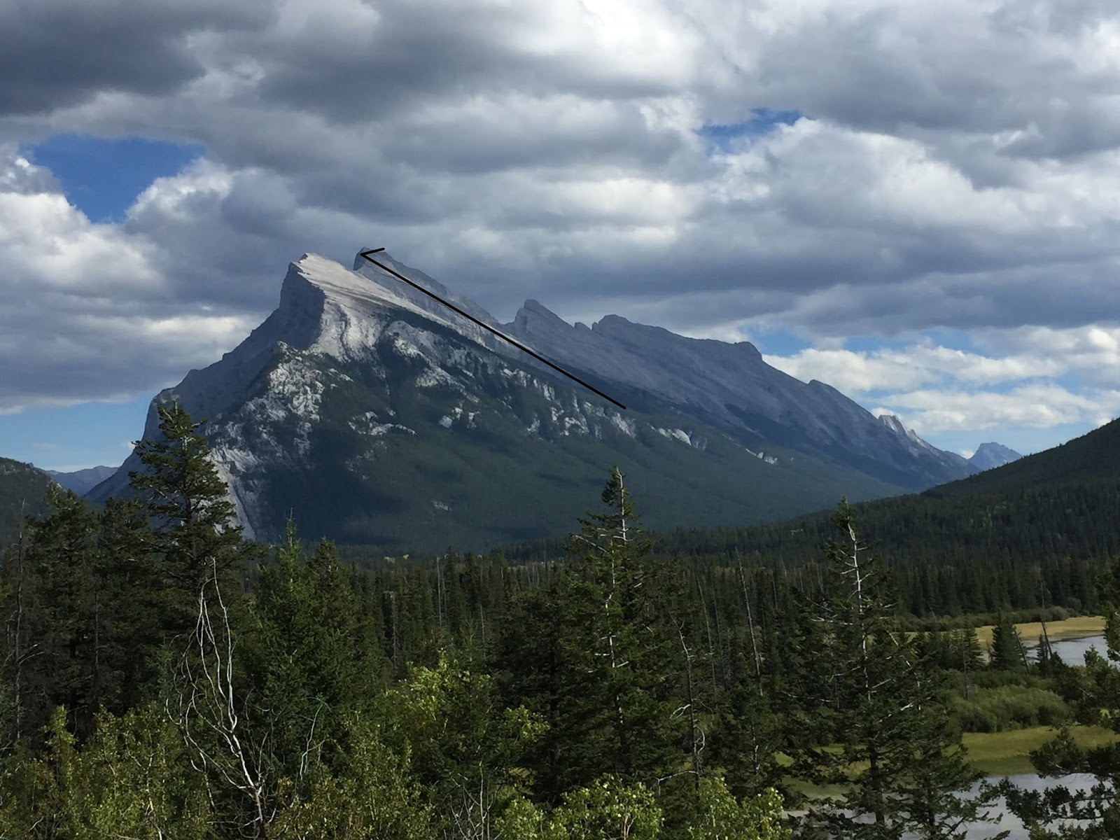
You could clearly see the route to the summit for the last 1.25 miles that climbed 3,100 feet. I outlined it here, which gives you a bit of perspective.
Comments